
Delivering high-value, low-cost and low-impact seismic in Australia
Obtaining permits to work from land owners can be difficult. Utilising low-impact technology that will minimise environmental footprint and land disruption is therefore key in helping obtain your permit to work and getting access to the land you want to survey.
Reducing the time spent surveying environmentally sensitive locations will help ensure projects are sanctioned. Survey design and the seismic acquisition technology you use can help overcome challenges in obtaining approval to work in environmentally restrictive areas.
Seismic source methods are expensive to operate and incur additional environmental impact and footprint. By using affordable and miniature receiver devices, you can increase your receiver spread and minimise source effort
Transportation and deployment can be a challenge in complex or remote terrains and can incur additional costs, environmental footprint, time and risk. By using small and lightweight receiver nodes, survey teams can carry thousands of receiver devices in just one vehicle, bury nodes in difficult or rocky terrain with ease and faster than ever before, and reduce seismic operational footprint.

At the heart of our solution is the STRYDE Node™, the world’s smallest, and most affordable seismic sensor, meticulously designed to help companies create a high-resolution image of subsurface in the most efficient, environmentally friendly, and cost-effective way possible.
Our solution helps companies assure seismic exploration and production optimisation projects are approved by supplying high-value, low-cost and low environmental impact seismic.
Exploring for energy and mineral resources across Australia requires seismic technologies capable of operating efficiently across vast, remote, and often harsh environments. High-resolution seismic data is critical for imaging complex subsurface geology, supporting resource exploration, and reducing drilling risk. However, conventional land seismic systems are often bulky, expensive, and logistically challenging to deploy across remote regions with limited infrastructure.
STRYDE is transforming land seismic acquisition. We have developed the world’s smallest, lightest, and most cost-effective autonomous seismic receiver technology, designed to enable high-density seismic surveys in even the most demanding onshore environments.
STRYDE nodes allow operators to efficiently acquire ultra-high-resolution seismic data across Australia’s deserts, remote basins, and rugged terrain. Their compact and lightweight design simplifies logistics, accelerates deployment, and reduces operational costs, enabling faster, more efficient seismic surveys while delivering superior subsurface imaging for energy and mineral exploration.
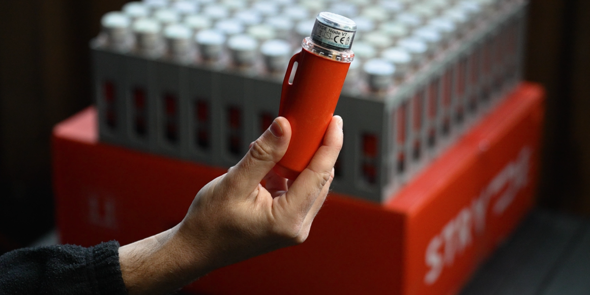
The world's smallest, most affordable seismic nodes available on the market enables high-density data acquisition to be affordable, delivering high-resolution seismic imaging.
Reduce survey time at every stage of operations, from logistics and shipping to deployment, retrieval and data recovery - enabling informed decisions to be made more efficiently
Reduce survey time at every stage of operations, from logistics and shipping to deployment, retrieval and data recovery - enabling informed decisions to be made more efficiently
Smaller crews and fewer transportation vehicles are required due to the miniature traits of the node, and being able to efficiently and safely deploy thousands of nodes by foot reduces exposure to HSE risk

High-density seismic will enhance image quality and will better map challenging shale and sand layers in complex geology. This technique will therefore help companies fast-track data processing and ensure data is interpreted accurately to enable informed decisions to be made faster.
Until recently, sensitive environments where cultural heritage restrictions or land access resulted in seismic being difficult or impossible to obtain suffered from sparse acquisition which delivered random and sparse geometries and incurred additional processing time and difficulties in interpreting the data.
Being able to deploy significantly more receiver devices like STRYDE's miniature nodes at the same price of a conventional survey will result in denser seismic with reduced environmental footprint and will eliminate blind spots to help fast-track and better reconstruct the subsurface image during processing.
“I'm sold on STRYDE. Working with STRYDE has been a great experience. Without their technology we wouldn’t even dream of doing some of the acquisition projects that we do, simply because of the amount of time, equipment, and cost, not to mention the environmental footprint, traditionally associated with seismic activity."

Managing Director, Oceania Geo
Pad3D is a bespoke production enhancement solution delivered by STRYDE and Oceania Geo, offering high-resolution seismic data to identify production enhancement opportunities by delivering rapid drill ready subsurface images for time critical drilling decisions.

Access drill ready products for time critical decisions in as little as 1 week
It costs ~AUD$100k-$250k to de-risk a 3-5sqkm multi-well pad development project using seismic data, horizontal well drilling costs $2m+ per well - which would you choose?
Access drill ready products for time critical decisions in as little as 1 week.
With the latest technology advancements resulting in smaller equipment and agile crews, seismic is a now cost effective solution, whilst still using high-energy sources and producing high value data.
Smaller scale equipment and crews allows for a flexible and tailored survey design and constraints with land owners and traditional owners are reduced due to lower impact, reduced footprint and less time on land.

Learn more →

Learn more →

Learn more →

Learn more →