Reducing costs and survey time in high-risk environments:
O&G exploration case study
In a security-sensitive region of Pakistan, Al-Haj Pakistan Exploration Limited (Al-Haj) set out to acquire an 150 km 2D seismic survey to appraise a recent discovery and advance a portfolio of mature exploration prospects. Operating in such an environment required more than just high-quality data - it demanded a seismic solution that could be deployed rapidly, operate discreetly, and minimize on-the-ground footprint to ensure personnel safety and control security-related costs.
To meet these challenges and demands, Al-Haj leveraged STRYDE’s Nimble Seismic Data Acquisition System, enabling a fast, lean, and discreet acquisition approach without compromising data quality. The survey was executed efficiently with a significantly reduced costs and operational footprint, while still delivering seismic data of a standard comparable to legacy cabled systems traditionally used in the region.
This case study explores how the combination of innovative nodal technology and agile field operations allowed Al-Haj to safely and cost-effectively acquire high-resolution seismic data in a complex operating environment.
To reduce subsurface uncertainty around the newly identified accumulation and to re-evaluate legacy prospects that had remained undeveloped due to limitations in historical seismic data quality and resolution.
A structurally complex, mountainous, and security-sensitive survey area in Pakistan.
2D reflection seismic survey.
This geometry provided dense inline sampling with wider crossline spacing, optimised for high-resolution structural imaging along profiles while maintaining operational efficiency across the survey area.
The STRYDE Nimble Seismic System, equipped with 2500 nodes.
Explosives.
A total of 6,000 receiver points were deployed with a receiver spacing of 20 m along the lines, and approximately 1 km between receiver lines.
3,000 source points using explosive sources, with a source spacing of 40 m along the lines.
Sajjad Akhtar
Head of Exploration, Al-Haj Pakistan Exploration Limited
“It’s an awesome system that reduces survey costs and accelerates acquisition without compromising data quality. It’s also ideally suited for operations in high-security environments and areas prone to theft.
In Pakistan, security risk and cost is always our biggest challenge when it comes to seismic surveys. It can account for up to 50% of total project costs and often leads to delays or even cancelled surveys.
Reducing the number of personnel in the field was critical, and that’s where the STRYDE system made a real difference. By operating with a much smaller crew, we significantly lowered both our exposure to risk and overall security costs.
Using STRYDE, we successfully acquired 150 km of 2D seismic data in a mountainous, security-sensitive area with minimal security presence, no incidents, and excellent operational efficiency. Deployment and retrieval were completed in just two days - around twice as fast as conventional systems.
Most importantly, the data quality was very good and fully comparable to other seismic systems we have used.
This project demonstrates that with the right technology, it is possible to acquire high-quality seismic data safely, quickly, and cost-effectively - even in the most challenging environments.”
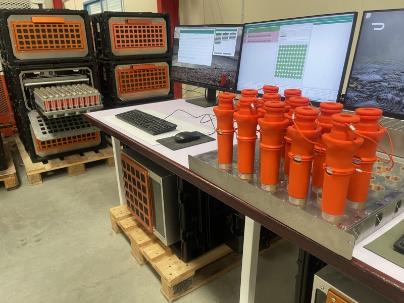
The STRYDE Nimble system is a lightweight, cable-free nodal seismic acquisition solution engineered to deliver high-density surveys with a minimal logistical footprint and reduced cost.
Designed for efficiency and operational flexibility, the system integrates compact autonomous nodes with streamlined deployment, recording, and data handling workflows. This makes it particularly well suited for challenging, remote, and security-sensitive environments where simplicity and speed are critical.
The Nimble system can handle up to 3,240 nodes per day with just a single operator, enabling highly efficient field operations. On this project, approximately 2,500 STRYDE nodes were deployed in a rolling spread to acquire 150 km of 2D seismic data across a mountainous and remote region of Pakistan.
Its lightweight and compact design enabled the use of smaller field crews, significantly reducing the number of personnel required on site. This not only improved operational efficiency but also lowered exposure to risk and reduced overall security-related costs.
After undergoing advanced seismic data processing by a seismic processing contractor, the data is now with Al-Haj’s experienced team of geologists and interpreters for detailed analysis.
These insights will play a critical role in maturing new exploration prospects across the region, enabling more confident and data-driven decision-making.
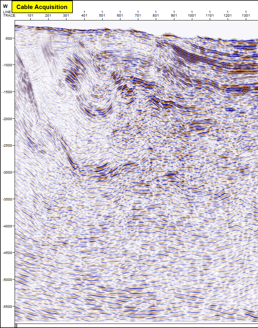
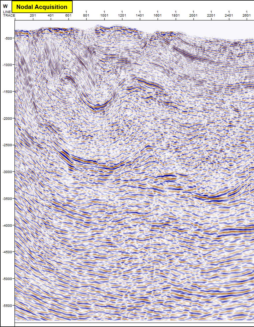
Below is a view of the legacy cabled seismic data vs the new high-density nodal seismic data from the same area in Pakistan: